
A short distance from the top of the pass a rill ‘about three feet broad and a few inches deep’ issued ‘from underneath an insulated block of mica slate’. In front of the rock a low wall of loose stones formed three sides of a quadrangle with the side next to the stream left open to allow access to ‘its presiding genius, Byas Rishi, of whom a small image, about a foot and a half high, stood against the wall nearest the rock’. Although sculptured out of hard stone, the image was ‘much worn, apparently by time and exposure’. Within the walls of the shrine ‘strewed flowers’ were left as offerings to the Rishi. In August 1820, the pioneering veterinary surgeon and Himalayan explorer William Moorcroft, together with his companions George Trebeck and Dr Guthrie, oversaw the construction of a small pile of stones. This was to serve ‘as a memorial of the first visit paid by a European to the source of the Byas’.
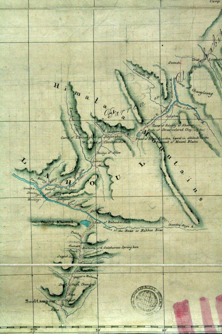
Leaving the shrine to Beas Rishi, Moorcroft ascended the few hundred additional feet to the ‘ghat or pass of Ritanka Joth’. Trebeck’s barometer tube measured the altitude to be 13,300 feet (4053 meters). The party continued north, crossing from Kullu into Lahoul. Moorcroft’s caravan was made up of several hundred porters, an escort of 12 Gurkas, sixteen horses and mules, and £4,000 of trading goods and examples of European production with which Moorcroft hoped to establish political relations and commercial ties with the people of Turkestan. To do so, Moorcroft had to cross several hundred miles of ‘barren and uninhabited waste’. His journey from Sultanpur (then capital of the Kullu Raja), over the Rohtang Pass to Keylong and the Baralacha La (‘equal in altitude to the summit of Mount Blanc’) was recorded on this map.
Moorcroft spent the next five years travelling throughout the Himalayas, Afghanistan and Central Asia, eventually reaching Bukhara, in present-day Uzbekistan. He was reported to have died shortly afterwards – possibly of fever or possibly by poisoning. Some say, however, that this native of Ormskirk in Lancashire lived on for another twelve years in the Tibetan capital at Lhasa. I’d like to think this is true.
Following Moorcroft visit, it was to be another ten years before another European traveller made the journey between Kulu and Lahoul. One of three brothers from Aberdeen who had made the exploration of the Western Himalayas something of a family business, Dr. James Gerard’s account of his Observations on the Spiti Valley and Circumjacent Country within the Himalaya’ culminates with his crossing the ‘pass of Rotang’ This ‘depression of the Himalaya’ was, by Dr Gerard’s estimate, ‘as low as thirteen thousand feet,’ (Gerard, J.G., 1833: 275).
The next European traveller along this route was the somewhat shady Dr John Henderson. With an East India Company arrest warrant issued in his name, Henderson had slipped over the Sutlej and made his way through Kulu and on to Ladakh and eventually Kashmir. Understandably given the circumstances of his travels, the detail of Henderson’s journey go unrecorded. There do however exist the reminiscences of those he met along the way and his name is remembered by later explorers of the region: Alexander Cunningham lists Henderson among the ‘three different travellers’[1] who had visited the source of the Beas prior to his own first visit in 1839.
Carried out in the rainy season of 1839, the object of Cunningham first journey into the Himalayas was ‘to ascertain the sources of the Punjab rivers’. Cunningham was further tasked with collecting ‘every kind of information that we thought might be useful and interesting regarding the countries through which we were to pass.’ (Cunningham, Alexander, 1841a: 1). Reaching the source of the Beas on the 7th of July, Cunningham and his travelling companion Lieutenant Broome located the block of mica slate mentioned by Moorcroft:
‘On the top of this block we built a pile of stones, and in the midst erected a slab on which we inscribed our initials…. The heat and glare reflected from the snow were intolerable, and our faces were completely blistered. From this the view of the snowy peaks of Tartary, the land of undissolving snow, was extensive and beautiful. Three thousand feet beneath us rolled the Chundra river, which even there was a deep stream, 100 feet wide; and on all sides was dazzling snow, from the midst of which towered the gigantic mountains’ (Cunningham, Alexander, 1841a: 4)
Following the first Anglo-Sikh war, Cunningham made further exploratory visits to the ‘Tibetan frontier of Ladak’ as part of a border commission deputed ‘to ascertain the ancient boundaries between the two countries, and to lay down the boundary between the British territories and those of Maharaja Gulab Sing’ (Cunningham, Alexander, 1854, P13). Given their task Cunningham’s second account of his crossing of the Rohtang Range is predictably filled with factual data:
‘The ascent from Lés-dhar to the top of the Pass was gentle and easy. There was no snow on the Pass, and we were able to trace the Byas river to its actual source, 300 yards beyond the block of mica slate noticed by Moorcroft, to a ridge of mica slate at the top of the Pass, from beneath which it trickles forth in a gentle rill… The Pass in 13,000 feet above the sea. The descent from the top of the Pass to Koksar, the first village in Lahul, was steep but easy; the distance about 5 miles.’ Cunningham, J.D., 1848, P211
After the external borders of the district had been determined, efforts began apace to ‘settle’ the revenue due payable by landholders and peasant farmers of the territory. George Carnac Barnes assessed the ‘wild and mountainous’ country of Kulu and Lahoul during the hot weather and rains of 1850 as part of his Regular Settlement of 1850-52. However the bulk of Barnes’ efforts concentrated on ‘Kote Kangra’ or ‘proper Kangra’. Only with James Broadwood Lyall’s Revised Settlement (1865-72) were Kulu and Lahoul given the same level of attention.
With the revenue settlement completed it fell to collectors to collect the land and grazing taxes and administrators to administer justice. Officials combined these duties with the writing of detailed reports about the districts and lands they were charged with administering. AFP Harcourt, Assistant Commissioner in Kulu from 1869-71 stands out as one of the best. Harcourt’s account of the Rohtang Pass provides further details for travellers:
‘The crest of the Rohtung is over a mile in length, and the pass is open from the end of April to the end of December; but in the early summer, and again towards the autumn, it is liable to severe snow-storms, accompanied with a deadly cold wind’ (Harcourt, A.F.P. 1874,p25)
The sinister reputation of the Rohtang Pass was confirmed by a tragedy that occurred late in the crossing season in 1863. Owing to an unusually early fall of snow which took place in October of that year, the workmen employed in constructing a wooden bridge over the Chandra river at Koksar were paid up and allowed to leave for their homes in Kulu. Reaching the summit of the pass the day’s earlier fine and clear weather had turned serious.
‘[the men] were met by a gale of wind so fierce and so cold, that, exhausted with struggling against it, numbed with cold, and blinded by snow which was caught up and driven in their faces by the wind, no less than seventy-two persons perished. A few days after, when the pass was visited by our officials to recognize and bury the dead, the scene was most ghastly.’ (Egerton, 1864: 7).
That very year the Governor-General Lord Elgin opted to cross the Rohtang Pass and make the return to Kulu on the same day: ‘a feat that few Englishmen would care to undertake’. (Harcourt, A.F.P. 1874,p25). The aggravation of a heart complaint that shortly after led to Elgin’s death was popularly attributed to his ‘over-exertion in crossing this pass’ and ‘the rarificaiton of the air at such a height’ (Egerton, 1864: 71).
It has been said that there was no sufficient cause for Lord Elgin, as Viceroy, encountering the difficulties of this pass, and that his life was sacrificed needlessly. But it is not surprising that Lord Elgin should take great interest in the improvement of a route which leads us at once into the heart of Asia. Nor can the subject be deemed unimportant; and his political connection with the Chinese Empire would doubtless enhance to him the interest which must attach to every scheme for improving our commercial intercourse with that jealous nation.’ Egerton, Philip Henry, 1864, P7.
Made aware of its importance as a route of trade and communication, the new government responded with efforts to improve the road over the pass. Harcourt expressed the wish that the ‘unremitting attention to his duties’ of the German engineer Mr Theodore, should not be forgotten or go unrewarded: ‘for weeks at a time, has Mr. Theodore been living almost at the top of the Rohtung, over 13,000 feet in height, and undaunted either by the desertion of his servants, the disobedience and impertinence of the workmen, and the rigours of the climate’ (Harcourt, A.F.P., 1874: 16).
With the journey made easier, by the late 19th century, a steady stream of travellers began to establish a tourist trail from Shimla or Kangra through Mandi to Kulu and on to Ladakh, Kashmir or Spiti. Keen to document their travels and describe how others might repeat them, resulting accounts combine dramatic tales of adventure with practical details of camping places, payments to coolies, distances between camps, and so on.
Mrs Murray-Ainsley left England with her husband in Oct 1875. Arriving in Bombay they travelled up country to Delhi, Kashmir and Ladakh taking in a journey from Shimla to Kulu to Lahoul between July and September 1878.
In her short but vital sketch of crossing the Rohtang Range she describes ‘being obliged to pick each step with greatest care’ over a snow-field upwards of a mile in length. Having traversed about two-thirds of the distance, ‘a dense mist came on, and we were obliged to make a coolie walk a yard or two in advance to show us the way.’ (Murray-Aynsley, 1879, P283)
A few years later the Rohtang Pass provided the first experience of trans-Himalayan travel for a young subaltern who would later bloodily lead the first British expedition to Lhasa. Having been granted two and a half month’s leave from his regiment, Francis Younghusband wanted ‘just to have a glimpse of what the country was like on the far side of that wall of the Himalaya’ (Younghusband 2000: 31). Younghusband’s account of his 1884 ‘dash into Lahoul’ is worth quoting in some detail not least for its unfavourable description of the Rohtang Pass. Contrary to Younghusband’s expectations of a ‘desperate climb along knife-edge ridges’ he was subjected to ‘a dull grind up a steep hill-side for a mile or two, and then nothing but dull plodding through soft snow for all the rest of the way to Kokser on the far side’ (2000: 36).
“You begin to wonder what on earth induced you to come to such a place, and only your pride keeps you still plodding on. So I kept on at it, feeling every more miserable the higher I ascended. At length I reached a fairly level stretch. Ahead was a wide expanse of dazzling snow, and above this, straight in front of me and apparently rising from it, was a jagged line or rock with spiky peaks, and over this, I took it, I had to climb. This I imagined was the pass. It did not look so very far distant – three or four miles – and I could make out almost all the details. So preparing for this as my final struggle I persevered on. When all of a sudden – to my astonishment – I came to a point where the snowy expanse suddenly dipped downward: and there deep below me was the narrow valley of the Chenab River, and that ridge of spiky peaks I had thought was the pass was really the range on the far side of the Chenab. I was, in fact, already on the summit of the Rotang Pass, and my climb was over.’ (2000: 37-38)
Relieved to find there was no more climbing, Younghusband ‘ran down the snow on the far side to get to warmer levels as soon as possible’. But on the whole he was disappointed: ‘I felt a sense of disillusionment. I had counted so much on this view from the top of the pass: and I found not very much in it. When you are already at 13,000 feet, a 20,000-feet peak does not look especially high.’ (2000: 38).
Younghusband stopped one night in an ‘icy and comfortless’ Rest House at the bottom of the valley (2000: 41). The next day he hurried back to Kulu.
‘The ascent from Lahoul back to the top of the Rotang Pass was fearfully steep and very slippery. And when I reached the top I found clouds were collecting, and by the time I reached Rala rain was falling” (2000: 42 to 43)
By this time the Kangra and Kulu valleys were becoming popular with European settlers. Younghusband had visited his uncle Robert Shaw’s tea estate. Another couple who made the Kulu valley their home were Mr and Mrs Tyache. In a series of instructive manuals the couple outline their hunting and fishing expeditions in the area. Mrs Tyache’s book ‘How I shot my bears’ describes an expedition up the Rohtang Pass made during a break in the monsoon in early September 1891. Starting their ascent at 6am so as to avoid the winds on the pass, the Tyaches reached the top in time for a picnic of ‘cold meat and chop-patties, washed down with iced whisky and water’, (Tyache, R.H., 1893, p118).
‘The top of the Pass is the line of demarcation between Kullu and Lahoul… you enter a country without trees, with scant vegetation, and sparsely inhabited, a country of rock, glacier, and blue sky’, (Tyache, R.H., 1893: 74-75).
Alongside trekking and hunting, Kulu and Lahoul also offered opportunities for serious mountaineering. It was this as much as the ‘magnificent flowers, rivers, picturesque scenery [and] interesting people’ that attracted C.G. Bruce to the area when he was granted seven months leave in March 1912. Bruce was accompanied by his wife, a Captain Todd and Heinrich Fuhrer a guide of Meringen and of Gstaad. With him also were two Gurkha servants, two Gurka orderlies, dogs and ponies. Not surprisingly given his skill in mountaineering, Bruce had not problems with crossing the pass
‘The Rahtang Pass itself is cross by an excellent path, fit for riding and mule transport; and if the roadway were a little smoother, it would almost be possible to pull a rickshaw over it when the snow is once off… It is at the very head of the long sleeve of the Kulu Valley, and is also rather a windtrap in itself, and I can quite imagine that anyone caught in bad weather very early or late in the year would be likely to have a very bad time indeed’ (Bruce, C.G., 1914: 47-48)
The final account included in this review is unusual in that Henry Lee Shuttleworth tackled the Rohtang Pass from the Lahoul side. Shuttleworth, together with his wife Inez, commenced on a walking tour of the district for which he was the assistant commissioner from 1917 to 1919 and again in 1923 and 1924. Striking off west from Banjara, they ascended the Pin Parbati pass to enter into Spiti before looping round into Lahoul. Their 490 mile tour was completed by returning to Kullu via the Rohtang ‘the winter accumulations of which are 40 feet or more deep in late February’ (Shuttleworth, 1922: 245).
The reasons for the popularity of the Rohtang Pass as a means to cross the Pir Panjal range are easy to understand. At a relatively low 3800 meters and easily assessable to mules and horses, the Rohtang Pass often featured on the itineraries and subsequent travel accounts of European travellers from the early decades of the nineteenth century. The above outlined accounts of crossing the Rhotang Pass follow a familiar path of Himalayan travel over the 19th century which commences with exploration (Moorcroft) moves through to survey (Gerard; Cunningham) and to on demarcation (Cunningham), revenue settlement (Barnes; Lyall), administration (Harcourt; Shuttleworth); scientific investigation (Holland) and on to the mountains as a site of leisure in the from of hunting, trekking and climbing (Tyache; Whistler; Yonghusband; Bruce). The descriptions left by these ‘pass crossers’ were drawn from a range of sources – private letters, personal diaries, official publications, administrative records, travel narratives. Journeys were also recorded in sketches, drawings, maps, collections, and photographs. Spanning over a century (1820-1922) and written for a range of different purposes and audiences, these accounts reveal much about European attitudes to the borderland between India, Kashmir and Tibet.
Today the Rohtang Pass has become a playground for holidaymakers and honeymooners from Delhi and the cities of the Punjab. From the resorts of the upper Kullu valley, a regular stream of Maruti minivans ferry happy passengers up to 3800 metres. Along the way they stop to hire fake fur coats and winter boots and to drink chair (or something stronger) at the colourful collection of shops at Muri. On reaching the flat expanse of the pass families ride tired ponies or jump across the few patches of dirty snow that have survived the heat and rain of summer. Operations are underway to tunnel through the Pir Panjal range between Kullu and Lahoul allowing commercial trucks and army vehicles year round access to Lahoul and shorter journey times to Ladakh. The expected completion date is sometime in 2019.

[1] Cunningham acknowledges only European born travellers – Moorcroft, Trebeck and Gerard. Guthrie, being of mixed Anglo-Indian heritage, was unfairly excluded from this list.
Bibliography
Alder, Garry, 1985. Beyond Bokhara: The Life of William Moorcroft, Asian Explorer and Pioneer Veterinary Surgeon 1767-1825. London: Century Pub.
Bruce, C.G., 1914. Kulu and Lahoul. London: Edward Arnold
Cunningham, Alexander, 1841a. ‘Abstract Journal of the Routes of Lieutenants A. Broome and A. Cunningham, to the sources of the Punjab rivers’. Journal of the Asiatic Society of Bengal, Vol. X Jan to June 1841, No.109, p1-6
Cunningham, Alexander, 1841b. ‘Abstract Journal of the Route of Lieutenant A. Cunningham, Bengal Engineers, to the sources of the Punjab Rivers’, Journal of the Asiatic Society of Bengal, Vol. X Jan to June 1841, No.110, p105-115
Cunningham, J.D., 1848, . ‘Journal of a trip through Kulu and Lahul, to the Chu Mureri Lake, in Ladak, during the months of August and September 1846’. Journal of the Asiatic Society of Bengal, vol. XVII, pp201-230
Cunningham, Alexander, 1854. Ladák, Physical, Statistical, and Historical; with Notices of the Surrounding Countries. London: W.H. Allen and Co.
Diack, A.H. (ed.), 1897. Gazetteer of the Kangra District. Parts II-IV: Kulu, Lahaul and Spiti. Lahore: Civil and Military Gazette Press
Egerton, Philip Henry, 1864. Journal of a Tour Through Spiti, to the Frontier of Chinese Thibet, with Photographic Illustrations. London: Cundall, Downes and Company.
Enriques, C.M. 1915. The Realm of the Gods; a tale of travel in Kangra, Mandi, Kulu, Chamba, Kishtwar, Kashmir, Ladakh and Baltistan. Calcutta: Thacker, Spink & Co.
Gerard, J.G., 1833. ‘Observations on the Spiti Valley and Circumjacent Country within the Himalaya’. Asiatic Researches, vol XVIII, pp238-278
Harcourt, A.F.P., 1874. The Himalayan Districts of Kooloo, Lahoul, and Spiti. Lahore: Government Civil Secretariat Press
Harcourt, Alfred Frederick Pollock, 1869. Our Northern Frontier: Being Observations on the recent advances of Russia towards Hindoostan, and the prospect of trade with central Asia. London: James Madden
Harcourt, A.F.P., 1871. ‘On the Himalayan Valleys: Kooloo, Lahoul, and Spiti’. Journal of the Royal Geographical Society of London, Vol. 41, pp245-257
Harcourt, A.F.P., 1870-1871. ‘On the Himalayan Valleys: Kooloo, Lahoul, and Spiti’. Proceedings of the Royal Geographical Society of London, Vol. 15, No.5, pp336-343
Harcourt, A.F.P., 1874. The Himalayan Districts of Kooloo, Lahoul, and Spiti. Lahore: Government Civil Secretariat Press.
Ibbetson, Denzil. 1883-84. Gazetteer of the Kangra District. Calcutta: Calcutta Central Press.
Lyall, J.B, 1874. Report of the Land Revenue Settlement of the Kangra District, Panjab, 1865-72. Lahore: Central Jail Press
Moorcroft, William, 1841. Travels in the Himalayan Provinces of Hindustan and the Punjab; in Ladakh and Kashmir; in Peshawar, Kabul, Kunduz and Bokhara; by Mr William Moorcroft and Mr George Trebeck, from 1819 to 1825. London: John Murray.
Murray-Aynsley, Mrs. J.C., 1882. An Account of a Three Month’s Tour from Simla through Bussahir, Kunowar and Spiti, to Lahoul. Calcutta: Thacker, Spink and Co.
Murray-Aynsley, Mrs J.C. (Harriet Georgiana Maria) 1879. Our Visit to Hindostan, Kashmir, and Ladakh. London: Wm. H. Allen & Co.
Shuttleworth, H. Lee, 1922. ‘Border Countries of the Punjab Himalaya’. The Geographical Journal, Vol.60, No.4 (Oct., 1922) pp241-263
Tyache, Mrs R.H., 1893. How I Shot My Bears; or Two Years’ Tent Life in Kullu and Lahoul. London: Sampson Low, Marston & Company.
Tyacke, R.H., 1893. The Sportsman’s Manual, in quest of game in Kullu, Lahoul, & Ladak, to the Tso Morari Lakes, with notes on shooting in Spiti, Bara Bagahal, Chamba and Kashmir, and a detailed description of Sport in more than 130 Nalas. Calcutta: Thacker, Spink and Co.
Whistler, Hugh, 1924. In the high Himalayas: sport and travel in the Rhotang and Baralacha, with some notes on the natural history of that area. London: H.F&G. Witherby
Wilson, Andrew, 1876. The Abode of Snow: Observations on a Journey from Chinese Tibet to the Indian Caucasus, through the Upper Valleys of the Himalaya. London: William Blackwood and Sons
Younghusband, Francis, 2000, (originally 1924. Wonders of the Himalaya. New Delhi: Srishti Publishers

Lord Elgin crossing and recrossing the Rohtang on the same day, as written by Harcourt, is an incorrect statement. From what I have gathered from “Letters and journals of James, eighth Earl of Elgin” by Warlond, Lord Elgin scended the Pass on 12th October 1863 and on the 13th he inspected a twig bridge over the river Chandra. He must have crossed the Pass on his return journey and not on the same day.
Correct me if I am missing something here.
LikeLike